topographic map
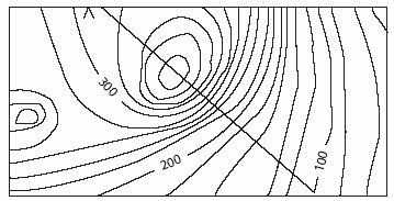
A map that shows the contours of the land via a two-dimensional drawing with multitudes of contour lines showing changes in elevations.Each map has its own scale.The contour lines indicate a change in elevation by the scale amount. For example, each line might represent a 1-foot change in elevation. The distance between the lines can be computed by reference to the distance scale.For example,1 inch might equal 50 feet.Two contour lines that are 1 inch apart would indicate a grade of 1 foot over the course of 50 feet, which is very gentle. The closer the lines on the topographic map, the steeper the incline.
The Complete Real Estate Encyclopedia by Denise L. Evans, JD & O. William Evans, JD. Copyright © 2007 by The McGraw-Hill Companies, Inc.